Point Cloud to BIM Modeling
Convert scan data into accurate, coordination-ready Revit models — LOD 200 to LOD 400
Convert your laser scan data into accurate, coordination-ready Revit BIM models — at LOD 200 to LOD 400, across Architectural, Structural, and MEP disciplines.
What Is Point Cloud to BIM Modeling?
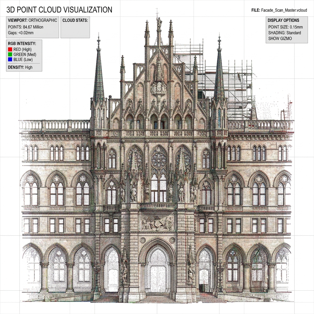
Point cloud to BIM modeling is the process of converting 3D laser scan data — captured by LiDAR scanners from manufacturers such as Leica, FARO, and Trimble — into an intelligent, parametric Building Information Model using Autodesk Revit.
The raw scan output, delivered in formats such as E57, RCP, or LAS, is processed, registered, and used as the geometric reference from which our BIM team builds a discipline-accurate Revit model at your specified Level of Development (LOD).
The result is a clean, coordinated BIM model that reflects the true as-scanned geometry of the building — ready for design development, construction coordination, renovation planning, or fabrication detailing, depending on the LOD you specify.
This service sits at the core of our Scan-to-BIM Services — the first step that transforms raw reality capture data into usable, intelligent building information.
Key Takeaways
- Laser Scan Inputs: Convert dense registered spatial datasets into parametric systems.
- Versatile Output: Coordinated models prepared for design revision or clashes check.
- Multi-discipline: Unify Architectural, Structural, and MEP systems cleanly.
- Standard Compliant: Follow strict BEP and international specifications.
Scan Data Formats We Accept
Our point cloud processing workflow accepts all major scan file formats from all leading laser scanner manufacturers.
| Format | Source | Compatible Scanners | Accepted? |
|---|---|---|---|
E57 | Open standard (ASTM) | Leica, FARO, Trimble, Z+F | ✓ Yes |
RCP / RCS | Autodesk ReCap | FARO, Leica, NavVis | ✓ Yes |
LAS / LAZ | Open LiDAR standard | Aerial, UAV, Mobile mapping | ✓ Yes |
PTX | Leica proprietary | Leica HDS, ScanStation | ✓ Yes |
XYZ | Generic ASCII | Multiple platforms | ✓ Yes |
PTS | Leica proprietary | Leica TPS, HDS range | ✓ Yes |
FLS | FARO proprietary | FARO Focus series | ✓ Yes |
If your survey team has delivered scan data in a format not listed above, send us a sample file. We will confirm compatibility and advise on any pre-processing required, at no charge.
Send a Sample File for Format CheckPoint Cloud to BIM Modeling — LOD Specifications
The Level of Development (LOD) you specify determines the geometric detail, embedded data, and downstream usability of your BIM model. We deliver models across the full LOD 200–400 range in line with the BIM Forum specifications.
Choosing the Right LOD for Your Project
| LOD | Element Detail | Accuracy Tolerance | Typical Use Case | Output |
|---|---|---|---|---|
| LOD 200 | Approximate mass and shape | ±50mm | Feasibility, planning, spatial analysis | RVT, IFC |
| LOD 300 | Precise geometry and dimensions | ±10mm | Design development, construction documents | RVT, IFC, DWG |
| LOD 350 | Interface and connection detail | ±6mm | Construction coordination, subcontractor packages | RVT, IFC, NWC |
| LOD 400 | Fabrication-ready detail | ±3mm | Steel, MEP, and specialist fabrication | RVT, IFC, NWC |
LOD 200 — Conceptual Mass Modeling
At LOD 200, elements are modeled as generic shapes representing approximate size, shape, location, and orientation. This level is appropriate for early-stage feasibility assessments, spatial programming, and planning submissions where exact dimensions are less critical than overall massing.
LOD 300 — Precise Geometry from Scan
LOD 300 models contain elements modeled to their precise geometry, with accurate dimensions, location, and orientation derived directly from the point cloud. This is the most commonly requested level for renovation design, construction documentation, and project handover.
LOD 350 — Construction Coordination
LOD 350 extends LOD 300 by adding interface detail — the connections, attachments, and spatial relationships between elements from different disciplines. This level is essential for multi-discipline coordination using Navisworks or BIM 360.
LOD 400 — Fabrication-Ready BIM
LOD 400 represents the highest level of geometric precision available from scan data. Elements include complete fabrication, assembly, and installation detail, modeled to ±3mm tolerance against the registered point cloud. Required for structural steelwork and complex MEP fabrication.
Not sure which LOD is right for your project? Our team can review your project brief and recommend the appropriate LOD for your downstream use case — at no cost.
Ask Our BIM Team About LOD SpecificationsDisciplines We Model from Point Cloud Data
We deliver complete, federated point cloud to BIM models across all three primary building disciplines within a single coordinated Revit environment.
Architectural Point Cloud to BIM
Our architectural modeling team captures the complete building envelope and interior fabric from your scan data. Deliverables include:
- External walls, internal partitions, and curtain wall systems
- Floor slabs, suspended ceilings, and roof geometry
- Doors, windows, and curtain wall framing — with correct family types
- Stairs, ramps, and vertical circulation elements
- Room boundaries and area calculations
Architectural models are delivered as native Revit RVT files with family content aligned to your project BIM Execution Plan (BEP).
Structural Point Cloud to BIM
Our structural BIM team models the load-bearing skeleton of the building from scan data with the precision required for structural engineering review:
- Reinforced concrete columns, beams, and flat slabs
- Structural steel framing — including connections at LOD 350+
- Foundation elements where visible in scan data
- Core walls, shear walls, and transfer structures
- Structural openings and penetrations
Structural models are delivered in RVT and IFC format, coordinated against the architectural model to eliminate internal clashes. See also our dedicated Structural BIM Modeling Services.
MEP Point Cloud to BIM
MEP coordination is where accurate point cloud to BIM modeling delivers its clearest return on investment. Our MEP team models building services from scan data:
- HVAC ductwork — supply, return, and exhaust systems
- Pipework — domestic services, process pipework, fire suppression
- Cable trays, conduit runs, and busbar systems
- Mechanical plant and air handling equipment
- Sanitary installations and drainage
MEP models from scan data are invaluable for renovation and retrofit projects. See our MEP BIM Modeling Services for standalone requirements.
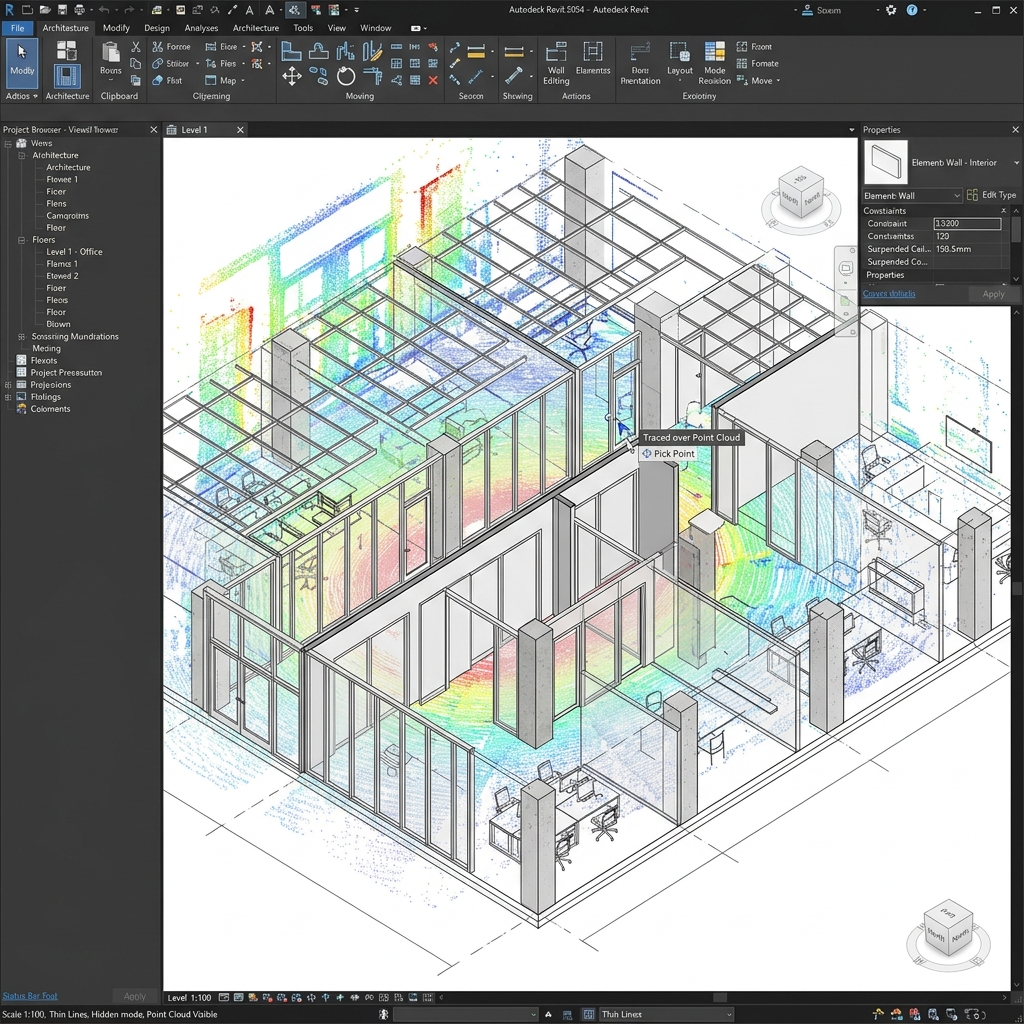
Our Point Cloud to BIM Modeling Workflow
Every project follows a structured, five-stage workflow that ensures model accuracy, client alignment, and on-time delivery.
Scan Data Receipt & Validation
On receipt of your scan files, our team performs a comprehensive data quality review. We assess point cloud density, identify gaps, confirm registration, and issue a validation report in 24 hours.
Point Cloud Registration & Cleaning
Where required, we perform or verify scan registration using ReCap Pro or Cyclone. Noise points, scanner artefacts, and temporary obstructions are cleaned from the dataset.
BIM Modeling in Autodesk Revit
Our Revit modeling team builds the model discipline by discipline against the point cloud, aligned with your LOD brief, BEP, and project standards.
Quality Control & Verification
Every model undergoes deviation checks (model vs. scan), parameter audits, internal clash checks, and schema validation before export.
Delivery & File Handover
Final deliverables are issued via secure transfer. Standard packages include RVT, IFC, and NWC. Additional formats (DWG, PDF, COBie) are provided on request.
Output Files and Deliverables
We deliver coordination-ready files and deviation documentation compiled for engineering and facilities use.
| Deliverable | Format | Included As Standard | Notes |
|---|---|---|---|
| Revit BIM Model | .RVT | ✓ Yes | Current Revit version |
| IFC Export | .IFC | ✓ Yes | IFC 2x3 or IFC 4 |
| Navisworks Cache | .NWC / .NWD | ✓ Yes | Coordination review |
| AutoCAD Export | .DWG | On request | 2D or 3D |
| PDF Drawing Sheets | .PDF | On request | Plans, sections, elevations |
| Point Cloud Deviation Report | .PDF | On request | Model vs. scan overlay |
| COBie Data | .XLSX | On request | Asset management data |
Software and Technology Stack
Our point cloud to BIM workflow is built on industry-standard, current-version software — the same tools used by leading AEC firms globally. We maintain current software subscriptions and update our workflows with each major Revit release, ensuring full compatibility with your project environment.
| Software | Role in Workflow |
|---|---|
| Autodesk Revit (2024/2025) | Primary BIM modeling environment |
| Autodesk ReCap Pro | Point cloud registration, cleaning, and Revit insertion |
| Leica Cyclone Register 360 | High-accuracy scan registration for Leica datasets |
| Trimble RealWorks | Processing for Trimble scanner datasets |
| CloudCompare | Open-source point cloud analysis and QA |
| Navisworks Manage | Clash detection and coordination review |
| Autodesk BIM 360 / ACC | Cloud collaboration and model coordination |
Industries We Serve
Our point cloud to BIM modeling services support AEC projects across a wide range of building types and construction sectors.
Commercial and Retail Buildings
Office towers, retail parks, mixed-use developments, and hospitality projects — where renovation, change of use, or fit-out refurbishment requires an accurate existing conditions model.
Healthcare and Hospital Facilities
Hospitals, clinical buildings, and specialist healthcare facilities — where MEP coordination from scan data is critical for infection control, infection route management, and programme certainty.
Industrial and Manufacturing Plants
Process plants, data centres, warehouses, and industrial facilities — where dense, complex MEP and structural installations require precise LOD 350–400 modeling for maintenance or decommissioning.
Rail and Transport Infrastructure
Stations, tunnels, depots, and transport interchanges — where dimensional accuracy and IFC interoperability are required for asset management and infrastructure renewal.
Educational Institutions
Schools, universities, and research facilities — where building stock requires condition surveys, refurbishment planning, or Estates BIM strategy development.
Heritage and Historic Properties
Grade I and Grade II listed buildings, conservation areas, and historic structures — where irregular, non-standard geometry demands specialist point cloud to BIM expertise.
Why AEC Firms Choose Us
We deliver verified spatial accuracy, multi-discipline capabilities, and fast delivery timelines.
BIM Specialists, Not Generalists
Our entire team works within the BIM environment — Revit, ReCap, Navisworks. We do not reassign general CAD drafters to BIM projects.
Accuracy You Can Verify
Every model is issued with a QA report confirming model-to-point-cloud deviation. At LOD 400, we work to ±3mm tolerance.
All Disciplines, One Team
Architectural, Structural, and MEP from the same project team eliminates coordination gaps and interface conflicts.
Format Agnostic Intake
E57, RCP, LAS, PTX — we accept your scan data as delivered by your surveyor. No pre-processing burden on your team.
Fast, Reliable Turnaround
Standard single-discipline LOD 300 models are returned within 3–5 working days. We communicate proactively about coverage.
Secure, Confidential Workflow
NDA available before file transfer. SFTP or SharePoint delivery. No third-party subcontracting without client consent.
Commercial Flexibility
Fixed-price project delivery or day-rate engagement — quoted transparently within 24 hours of receiving your brief.
Point Cloud to BIM — Project Portfolio
Real-world projects highlighting our LOD coordination and structural capabilities.
LOD 350 MEP and Structural BIM
12-Storey Commercial Tower
Scope: Federated MEP and Structural BIM model from a full-building E57 scan dataset, comprising 47 individual scan positions across 12 floors.
Disciplines: MEP (HVAC, pipework, cable tray) + Structural (RC frame and steel transfer)
LOD: 350 — construction coordination level
Output: Federated RVT + IFC 2x3 + NWC for Navisworks review
Outcome: 47 hard clashes and 23 soft clashes identified and resolved before subcontractor tender issue. Refurbishment programme started 5 weeks ahead of schedule.
LOD 300 Architectural BIM
NHS Healthcare Facility Refurbishment
Scope: Full-building architectural BIM model from RCP scan data — 3 buildings, 8,400m² gross internal area.
Disciplines: Architectural
LOD: 300 — design development level
Output: RVT + coordinated PDF drawing set (plans, sections, elevations)
Outcome: Architect confirmed model accuracy enabled scheme design without a return survey visit — saving 3 days of surveyor time.
Quality Assurance in Point Cloud to BIM Conversion
Accuracy is the single most critical performance requirement in point cloud to BIM modeling. A model that does not faithfully represent the scanned geometry creates design errors, coordination clashes, and construction risk.
Our QA process is structured to catch and resolve accuracy issues before any model leaves our team:
- Model-to-point-cloud deviation review: Every element is visually and dimensionally checked against the source point cloud before issue. Deviations exceeding the LOD tolerance are corrected.
- Family and parameter audit: All Revit families are verified against project BEP requirements. Custom families created for the project are documented.
- Internal clash detection: Single-discipline models are reviewed for internal clashes before issue. Federated models undergo full multi-discipline clash detection in Navisworks.
- IFC export validation: IFC files are validated using open-BIM checking tools to confirm schema compliance and element completeness.
- Client BEP compliance check: Where a BEP has been provided, deliverables are checked against its modeling and naming standards.
Our internal QA process reflects ISO 9001 quality management principles, with project records retained for audit and lessons-learned review.
ISO 9001 Alignment
Our workflows are documented, audited, and optimized to minimize deviation and guarantee coordinates registry alignment across multi-scanner setups.
Frequently Asked Questions
Find answers to common questions about formats, LOD levels, and turnaround times.
Point cloud to BIM modeling is the process of converting 3D laser scan data — captured by LiDAR scanners from manufacturers such as Leica, FARO, or Trimble — into a parametric Building Information Model in Autodesk Revit. The raw scan data, delivered in formats such as E57, RCP, or LAS, is registered, cleaned, and used as the reference geometry from which a BIM model is built at your specified Level of Development (LOD 200 to LOD 400).
We accept all major point cloud file formats, including E57, RCP, RCS (Autodesk ReCap), LAS, LAZ, PTX (Leica), XYZ, PTS, and FLS (FARO). If your survey team has used a scanner or software platform you are unsure about, send us a sample file. We will confirm compatibility within 24 hours, at no charge.
We deliver point cloud to BIM models at LOD 200 (conceptual massing), LOD 300 (precise geometry for design and documentation), LOD 350 (interface and connection detail for construction coordination), and LOD 400 (fabrication-ready detail for off-site manufacturing). The achievable LOD depends on your target use case and the density and registration accuracy of your source scan data.
At LOD 400, our models are verified to ±3mm tolerance against the registered point cloud. LOD 350 models are delivered to ±6mm, and LOD 300 to ±10mm. Accuracy is always dependent on the quality of the source scan data — we review scan coverage and registration accuracy at project inception and advise you of any limitations before modeling begins.
A single-discipline LOD 300 architectural model of a small to medium building (up to 2,000m²) is typically delivered within 3–5 working days of receiving clean, registered scan data. Multi-discipline federated models for large or complex buildings require 2–4 weeks, depending on building size, LOD level, and discipline scope. We provide a project-specific delivery programme with every quote.
Our workflow uses Autodesk ReCap Pro for point cloud processing and registration, Autodesk Revit (current version) as the primary BIM modeling platform, and Navisworks Manage for coordination and clash detection. We also use Leica Cyclone Register 360 for complex scan registration, CloudCompare for point cloud QA, and Autodesk BIM 360 / ACC for cloud-based project collaboration.
Point cloud to BIM modeling focuses on converting scan data into a Revit model at LOD 200–400 for design development, coordination, or fabrication. As-built BIM modeling specifically targets LOD 500 — the post-construction record model — and includes COBie asset data for FM handover and CAFM system integration. If your project requires a LOD 500 record model, see our As-Built BIM Modeling Services.
Standard deliverables include the native Revit model (.RVT), an IFC export (IFC 2x3 or IFC 4), and a Navisworks cache file (.NWC) for coordination review. We can also provide AutoCAD DWG exports, PDF drawing sheets (plans, sections, elevations), COBie data, and a model-to-point-cloud deviation report. All deliverable formats are confirmed in your project quote.
Start Your Point Cloud to BIM Project Today
Send us your scan files, project brief, and LOD requirement. We will return a detailed scope, LOD recommendation, and fixed-price quote within 24 working hours.
For large or complex projects, we offer a free pilot model on a sample area of your scan data before project commitment.